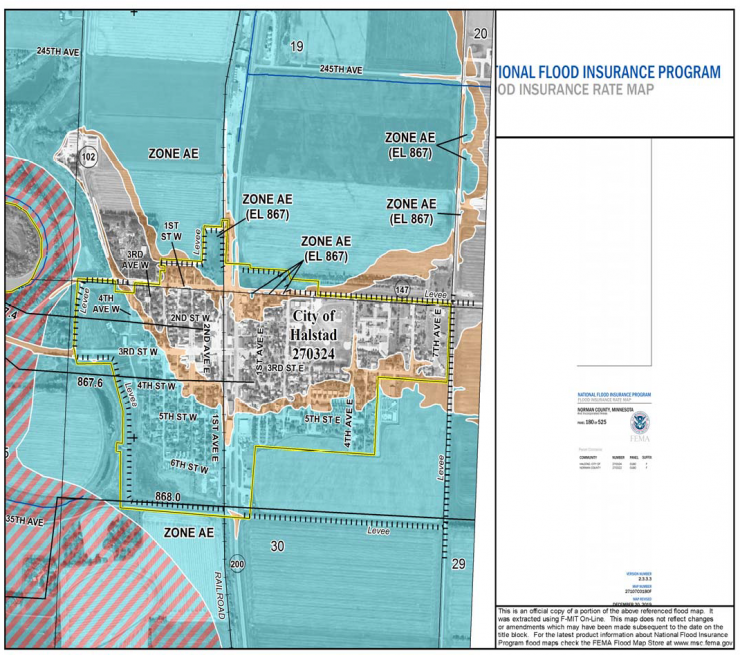

• The new FEMA Flood Insurance Rate Map will be effective for the City of Halstad on December 20, 2019.
• Levee upgrades and Hwy 75 road raises will be completed soon, but FEMA will not delay the effective date of the new Flood Insurance Rate Map.
• The new Flood Insurance Rate Map puts a portion of the City of Halstad in flood Zone AE; previously the entire City was in Zone X (certified levy) and flood insurance was not required.
• Some property owners will now be REQUIRED to have FLOOD INSURANCE if they carry a federally underwritten mortgage or loan.
• Flood Insurance policies will be significantly less expensive prior to the effective date of the new Flood Insurance Rate Map (December 20, 2019). Flood insurance policies are effective 30 days after purchase.
• The City strongly encourages property owners to contact a licensed insurance agent to review Flood Insurance options; prior to November 20, 2019.
• Please come to the public information meeting for more information and to get answers to any questions you have!
• Local insurance agents will also be available for questions
Click here to view a PDF of the notice.
If you are unable to attend the meeting, click here to view the presentation slides.
Recent Comments